Robert Fuller is a PHD student who studies Indigenous cultural astronomy at the University of New South Wales.
He was researching the astronomical knowledge of the Euahlayi and Kamilaroi Aboriginal peoples of northwest New South Wales when he came across “star maps” – a method used to teach travellers how to navigate outside of their local country.
Fuller found out that “star maps” were a means of teaching people how to travel during the day time outside of their own country.
“So if you think of a list of maybe six stars in a row, each of those stars is a point along the landscape on their trip and that point is something that they have to remember. So the person teaching is using those stars point by point to teach the person okay, your first stop is this water hole, and then the next star is the river you go to, and maybe the next star is the mountain. So it’s a memory aid, not so much a navigation aid.”
His teacher of this knowledge was Aboriginal leader Ghillar Michael Anderson, a Euahlayi Culture Man from Goodooga, near the Queensland and New South Wales border.
Anderson was one of the founders of the Aboriginal Tent Embassy set up in Canberra in 1972.
“So a lot of the star maps primarily focus on identifying pathways via water holes to and from ceremonial locations over vast distances and so you're looking at anywhere between five to six hundred miles.”

Source: 20160324-17835-1b2obi.jpg
The secrets of the stars were passed on by Anderson’s grandfathers when he became engaged with ceremonial activities in the 1960s.
He considers himself lucky to have learnt the wisdom directly from elders who were born in the late 19th century.
“That’s why I have that knowledge so strongly embedded within me because I learnt from grandparents and old people, who were grandparents of others, who learnt off their grandfathers, who were born before the white men came into our country.”
ack then, Indigenous Australians turned to the star maps to make decisions prior to traveling out of their own country.
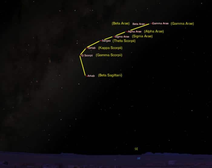
“Those star maps are most prevalent in the sky anywhere between August and September - these are the two months that give you direction and guidance. So, depending on the brightness of the stars, we will make our decision which way we’re going or whether we’ll be staying in our general location and go with the flow close to the ceremonies.”
Robert Fuller says the routes covered vast distances up to 700 kilometers long.
“They used to go to a place up near Quilpie from Goodooga, which is near the Lightning Ridge, and meet another group of Aboriginal people from the central desert area, north of Alice Springs. Those people would have traveled maybe 1500 km to meet the Euahlayi people for a ceremony and of course they must have used a similar method to teach people how to travel that long distance.”
Ghillar Michael Anderson says it takes a few months as we go across other people’s country.
“But we can only go if they send us invitation by way of a message stick and then we will carry that message stick on our spear to show because that’s our passport across their country; that’s an invitation, otherwise the tribes will not allow us to pass across their country.”
Complex trade routes were established across the continent prior to European arrival.
Scare resources and goods like stones, ochres and tools were traded to improve the quality of life for Aboriginal communities.
Robert Fuller says aside from goods, they were also trading stories and songs.
“We have a couple of instances where some older culture people have drawn some pictures of what Australia looked like before 1788 in terms of trade routes. It looks like a basket weave. There are so many of them it goes east to west and north to south and all over. Aboriginal people travelled quite long distances to trade.”
The star patterns enabled Indigenous Australians to memorise the waypoints to their intended destination.
What better way to teach the routes than by singing them?
The oral transmission of a travel route became known as a “songline”, also called a “dreaming track”.
“This was a song. The star map actually gave you the verses of a song so that you could then remember the instructions of how to travel and of course, that brings up the question of something called “songlines”. Now, songlines have been known about for a long time but not in any detail and songlines are actually routes across the Australian landscape which are encoded in the song.
Ghillar Michael Anderson says songlines have a special significance.
“Songlines on the earth are the ones that show you where the creators traveled and of course, these sacred places along the songline is where creation took place.”
Fuller’s research compared a couple of these routes up on Google Maps.
As he placed the push pins where the various points were on the route, he suddenly noticed that two of the routes were almost perfectly following the major roads on the map.
“This was from northern New South Wales, all the way up to Queensland, up to the Bunya Mountains, which are northwest of Brisbane, and all the way up to Carnarvon Gorge, which is up in central Queensland.”
These findings got Fuller thinking.
He reflected and realised that when early European explorers first set foot on this country, they would’ve had Aboriginal people as guides.
“For example, Major Mitchell, who traveled up to this country in about 1845. He had a couple of Aboriginal guides from down the Sydney way but those Aboriginal people would've asked the local people about what were the best routes to travel, and of course, these people would've told them these routes that they know very well, which are actually songlines, so Mitchell would've marked down these routes, and after Mitchell, would've come possibly the drovers, farmers, and eventually they would've had dirt roads for the carts, and eventually those dirt roads would've been turned into paved roads.”
The ancient songlines telling the story of the landscape are still alive after tens of thousands of years.
Many of the routes embedded in these songlines have turned into tracks and highways forming the modern Australian road network.
This audio feature was based on Robert S. Fuller's original article "How ancient Aboriginal star maps have shaped Australia's highway network" from The Conversation.